Find a Vent

Home The Library The Expedition

Find a Vent

How do scientists find hydrothermal vents located miles below the ocean surface? Climb aboard a virtual expedition, take charge of the ship's controls, and look for a deep sea vent.

The Library Learn all about vents
The Expedition Explore and find a vent
  • 1 Discovery
  • 2 Mid-Ocean Ridges
  • 3 Finding Plumes
  • 4 Finding Vents

Part One

Overview

An unexpected underwater landscape

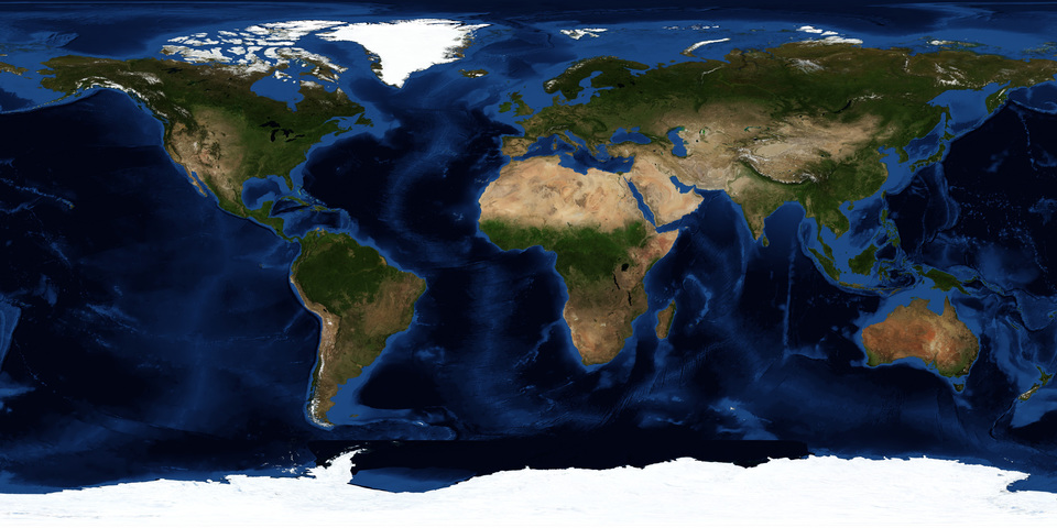
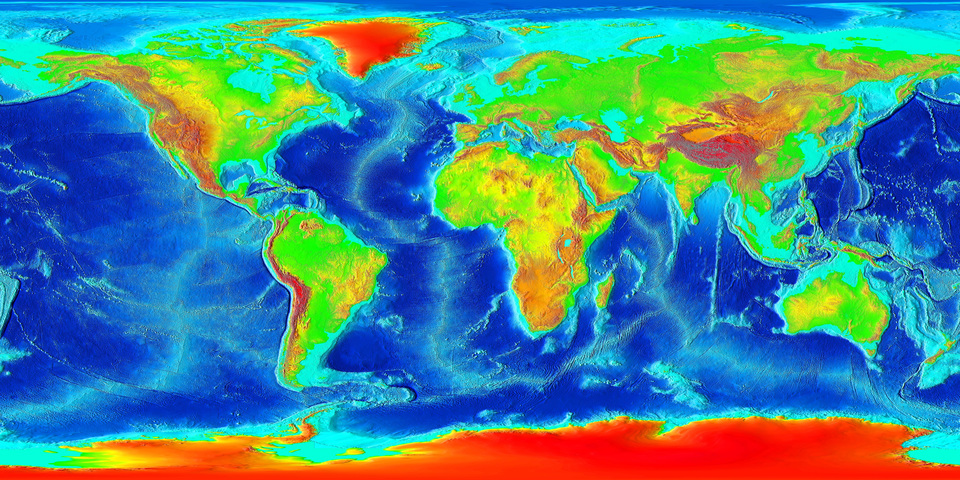
Take a look at this map of the Earth. Most of the planet is covered with water—and that's just the surface area. Imagine the huge volume of water beneath that expanse of blue! The bottom of the ocean is covered with mountains, valleys, volcanoes, and canyons, much like the part of the Earth we inhabit.

Life where you least expect it

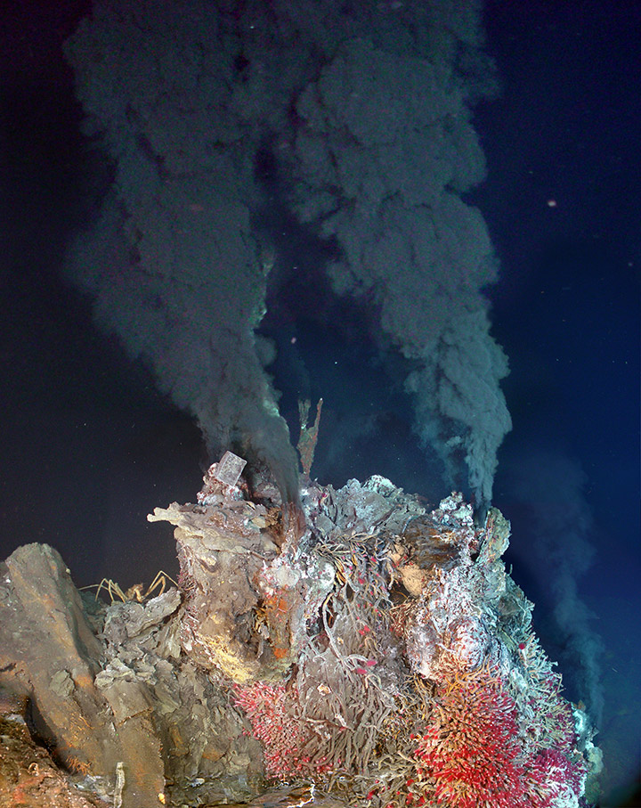
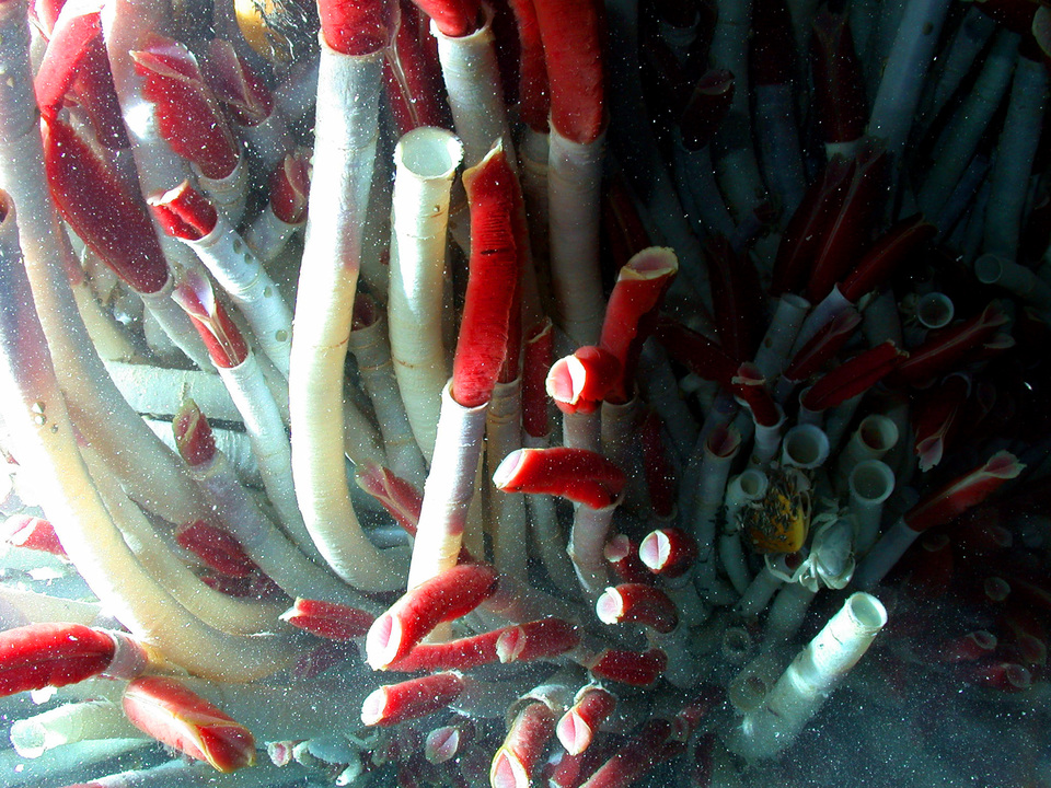
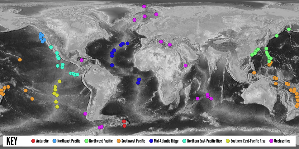
In 1977, scientists discovered hydrothermal vents on the deep ocean floor. These vents spew out fluids that are superheated by molten rocks beneath the seabed; fluids that in some places are hot enough to melt lead. Incredibly, dense communities of living creatures thrive in these sunless, superheated, mineral-rich waters—conditions once considered inhospitable to life.

Next Mid-Ocean Ridges

Part Two

Mid-Ocean Ridges

Where on the sea floor can vents be found?

Scientists are eager to find and study deep sea vents. Although the ocean is immense, numerous vents have been found so far along mid-ocean ridges (mountain chains that form at tectonic plate boundaries). This is just the beginning—only a small portion of the Earth's 50,000 kilometers of mid-ocean ridges has been explored. Detailed maps of the ocean floor point to areas worth investigating.

Warm-water plumes signal vents below

The first deep sea vent was found in 1977 near the Galapagos Islands by Earth scientists inside the Alvin, a small research submersible. But ALVIN moves very slowly and costs about $40,000 a day to operate, and time at sea is limited. The odds of finding a vent by chance, as those scientists did, are less than one in a million.

Instead, scientists at the surface use indirect methods to locate vents by looking for the large plume of warmer water that indicates a vent below. Because the plume is much larger than the vent, scientists have a better chance of detecting the plumes and then tracing it back to a vent, even if their ship has passed over the actual opening in the seafloor.

Click the image for an enlarged version with a list of hydrothermal site locations.

Next Finding Plumes

Part Three

Finding Plumes

Instruments are lowered from the ship

The principal tool that shipboard scientists use to look for plumes is a set of instruments called a CTD (Conductivity - Temperature - Depth) package. The CTD is prepared on board and towed by the ship.

The CTD package contains sensors that collect temperature and conductivity data. It may also include water-sampling bottles—the dark gray cylinders inside the metal frame in the photo—so scientists can analyze the water chemistry in a shipboard laboratory. The plume is both warmer and chemically different from the surrounding seawater, and the CTD package allows scientists to look for both chemical and thermal signatures.

When all of the equipment is checked and in place, the package is slowly lowered into the ocean. This requires a lot of teamwork. The captain and crew navigate; the bosun and marine technicians supervise the launch, the operation of the instruments, and the recovery of the package; and researchers and students monitor the data feed from the underwater instruments.

"Needle in a haystack"

As the scalding hot fluid comes out of a vent, it mixes with the cold seawater, cools significantly, and is moved upward and spread out by ocean currents. This mixed water ends up being only a fraction of a degree warmer than the surrounding seawater. The key to locating this plume is to measure the ocean temperature continuously, in the hopes of finding some temperatures (called anomalies) that are slightly higher than normal. Imagine pouring a cup of boiling water into a swimming pool. The pool water will become a tiny bit warmer in that spot, and this can only be detected by using a really good thermometer in just the right place.

On board, computers display continuous temperature readings in the form of graphs, which scientists study for temperature anomalies. Even very small differences are significant. There might be only one part of hot hydrothermal fluid (at 350°C) diluted in 300,000 parts of seawater (2°C), so a difference as small as .001°C is enough to warrant a closer look.

The "tow-yo" pattern intersects with plumes

Because the shape of a plume is irregular, it's easy to miss an anomaly completely. To increase the odds of encountering a plume, crew members drag the CTD in a vertical sawtooth pattern, up and down through the deep waters above the ridge. The pattern is called a "tow-yo," and can be several kilometers long. Several 'clouds' of heat may be detected during the course of a tow. They may represent plumes from several different vents.

Next Finding Vents

Part Four

Finding Vents

A vertical drop gives scientists a closer look

Once a significant anomaly has been found, the next job is to find the vent itself. Scientists might select one point inside the 'cloud' and lower the CTD directly down to the seafloor, recording temperature measurements along the way. Repeating this yields a vertical cross section of the plume, which might be 200 meters thick and several kilometers long. These temperature-anomaly profiles help pinpoint the vent more precisely. A temperature anomaly of just .4°C might indicate a position directly over a smoking vent!

Once the ship locates a vent, scientists send down a submersible or ROV (Remotely Operated Vehicle) to explore the environment and collect samples, specimens, images, and more data. It's a long and detailed process—and an exciting one.

Next The Expedition
Ocean floor map courtesy of Deborah Kelley (University of Washington)
  • 1 Find a Plume
  • 2 Plot a Route
  • 3 Drop Your Probes
  • 4 Send Down Your Submersible
30km
30

Step 1

Find a Plume

Click the map to take temperature readings at 200 meters above the sea floor.

What’s a plume?
A plume is a column of warm water that indicates a vent below. As the scalding hot fluid comes out of a vent, it mixes with the cold seawater, cools significantly, rises up, and is spread out by ocean currents. This plume of mixed water ends up only a fraction of a degree warmer than the surrounding seawater, but it is much, much larger than the vent below.
What instruments do I use to find one?
To locate a plume, you can use a set of instruments called a CTD (Conductivity – Temperature – Depth) package. The plume is both warmer and chemically different from the surrounding seawater, and the CTD package allows you to look for both chemical and thermal signatures at various depths.
Next Plot a Route

Step 2

Plot a Route

Click points along the map to plot segments of your route.

Your route is limited to 50km.

How do I find a plume?
To find a plume, crew members use a set of instruments called a CTD (Conductivity - Temperature - Depth) package. The package is towed by the ship and collects temperature and conductivity data. Since plumes are both warmer and chemically different from the surrounding seawater, the CTD package can help locate them.

Launch Ship

Get ready to take temperature readings! Launch the Ship and take readings as the ship is moving.

Take Readings

Click the reading button to take temperature readings along the path.

Narrow Your Search

Choose a line segment for your tow-yo.

What’s a tow-yo?
A tow-yo is a vertical sawtooth pattern that the CTD package follows up and down through the deep waters above the ridge. It can be several kilometers long. Several 'clouds' of heat may be detected during the course of a tow. They may represent plumes from different vents.
Next Drop Your Probes

Step 3

Drop Your Probes

Move the arrows to choose the drop points for your probes.

What’s a probe?
You are preparing to use the CTD package in its vertical mode. The ship will travel along the horizontal line you’ve selected and obtain temperature profiles along five vertical lines taken between 500 and 50 meters above the sea floor. These readings will yield a vertical cross section of a plume, which might be as much as 200 meters thick and several kilometers long.

Subsurface Probes

Review underwater temperature data from subsurface probes.

Next Drop Submersible

Step 4

Send Down Your Submersible

Now that you have the temperature readings, select one of the locations from which to send down the Submersible. Did you find a vent?

Drop Submersible

Awaiting Confirmation...

Drop Submersible

Sorry

You didn’t find plume or a vent.

Try Again

Congratulations!

You found a deep sea vent at this location!

Almost

Close! You found a plume but not a vent.

TryAgain

Welcome to the Juan de Fuca Ridge!

The Juan de Fuca Ridge stretches 300 miles (483 km) along the floor of the northern Pacific Ocean. Scientists have discovered many hydrothermal vents along the ridge. Help them discover another! Explore this unknown section of the Juan de Fuca Ridge for evidence of a vent. Then evaluate your findings and decide where to send a submersible. Good luck!

Get Started